
By Rohan Gunaratna
Satellite Imagery
The world’s largest commercial satellite data provider Planet has captured the Hamas safe house in Qatar before and after it was attacked by Israel on September 9, 2025. The Israeli operation, codenamed “Fire Summit,” identified the target as “Judgement Assembly.” A comparison of the images on January 24, 2025 and September 10, 2025 demonstrates the value of geospatial intelligence.
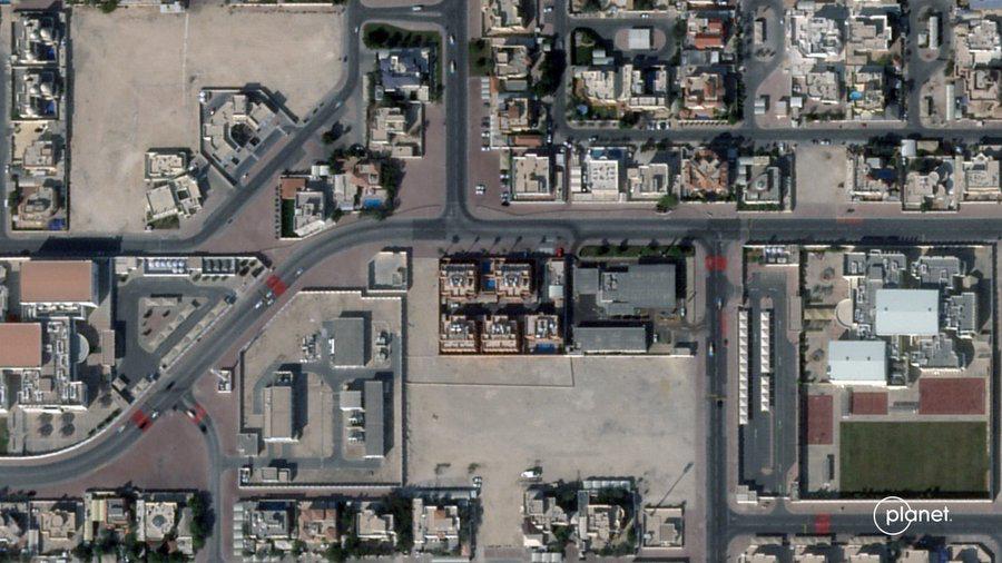
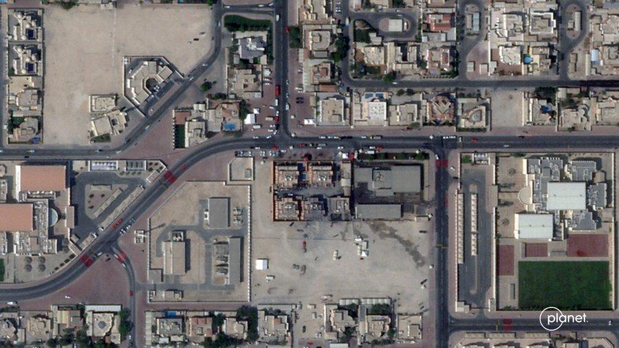
The Hamas politburo members met in their safe house located next to the petrol station in West Bay lagoon in the Katara District. According to Hamas, the attack killed:
- Humam Al-Hayya (Abu Yahya) – son of chief negotiator al-Hayya
- Jihad Labad (Abu Bilal) – director of al-Hayya’s office
- Abdullah Abdul Wahid (Abu Khalil)
- Moamen Hassouna (Abu Omar)
- Ahmed Al-Mamluk (Abu Malik)
- Corporal Badr Saad Mohammed Al-Humaidi – Qatari internal security forces
Modelling
AiTelly, a YouTube channel and animation content creator known for its original 4K 3D engineering animations, produced a high-quality 3D animations of the Israeli attack.
AiTelly produced a video of Israeli targeting of Hamas leadership in Doha in a residential building in the Katara District. They identified and modeled the exact building that was hit.
Of the five buildings lined up, with a petrol station right next door, the Israeli Air Force targeted the building without damaging the other four including the petrol station.
The successful strike was carried out against the one in the middle, using precision-guided weapons around 10 in numbers all launched at the same time.
AiTelly identify an American made G P S Guidance J dam, a Spike Laser Guided Bomb, or even a Rampage missile all used in multiple combinations.
Israel knew exactly which building to strike. Although Qatar Amiri Guard has been stationed around that structure 24 hours a day since the Hamas led massacre and hostage taking on October 7, 2023. AiTelly assesses that the heavy security presence was a giveaway.
Disciplines of Intelligence
Israel’s internal security agency, Shin Bet worked with the Israeli Intelligence Department and Air Force to develop sound and timely intelligence. To conduct the attack at the time the leaders met in the safe house, Israel integrated at least four disciplines of intelligence.
- human sources
- signals intelligence
- cyber intelligence
- satellite imagery
The integration of high grade-high quality intelligence enabled a precision-strike seeking to eliminate the Hamas leadership.
Designed for deep strikes, Israel’s F-35I “Adir” evaded radar and delivered precision stand-off munitions without entering hostile airspace. Mid-air refueling by a Boeing 7 “O’ 7-based aerial tankers enabled Israeli aircraft to fly to Doha and return back to Israel. The IAF fighters travelled 2000 kilometers one way avoiding radar detection.
The Future
Today, governments integrate various disciplines of intelligence to produce all source intelligence to ensure the success of their operations. All-source intelligence involves collecting and analyzing information from multiple different intelligence disciplines to produce a comprehensive and coherent understanding of a situation or threat. It combines data from sources like SIGINT (signals intelligence), HUMINT (human intelligence), GEOINT (geospatial intelligence), MASINT (measurement and signature intelligence), and OSINT (open-source intelligence) to provide actionable insights for informed decision-making in fields like national defense, cybersecurity, and private sector security.
Planet’s commercial imagery supports both policymakers and the academic community. GEOINT, including Planet’s satellite imagery, plays a key role when fused with HUMINT, SIGINT and CYBER. By weaving AiTelly’s modeling, the analysis becomes accessible when combined with Planet’s satellite imagery. A neutral commercial provider Planet enables transparency and verification rather than getting involved in operations.
In the future, land, ocean, air, cyber and space will be fully integrated. The Next-Gen Mapping will be with AI, GIS and satellite technologies are transforming the world. The pivotal role of commercial satellite imagery in contemporary intelligence frameworks is vital.
Conclusion
A phenomenon of the early 21st century is the democratization of intelligence. That is making intelligence more accessible, affordable, and usable by a wider range of people and organizations, rather than restricting it to a select few. This concept involves reducing barriers to entry in development and use, fostering greater collaboration, increasing transparency and oversight, and enabling public participation in shaping and governing these powerful technologies. To empower humanity, Planet is spearheading the democratization of intelligence.
Rohan Gunaratna is editor of the Handbook of Terrorism in the Middle East